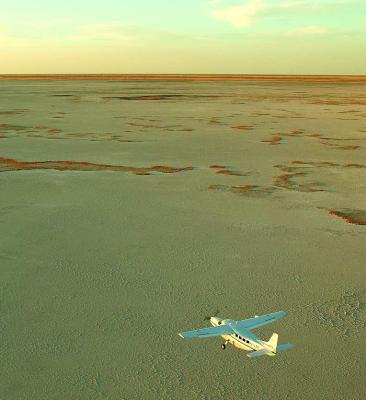

The Makgadikgadi, an area of 12 000 sq kms, is part of the Kalahari Basin and one of the largest salt pans in the world. The great grass plains of Makgadikgadi and the associated pan complexes of Sowa, Ntwetwe and Nxai are scenically stunning; the first-time visitor is invariably struck by the immensity of sky and horizon of the Botswana landscape.
The large pans of Makgadikgadi are the most visible remnants of a lake that has been formed more than five million years ago and it is probable that the pans held significant amounts of water for long periods of time as recently as 1 500 years ago.
For much of the year, most of this desolate area remains waterless and extremely arid; and large mammals are thus absent. But during and following years of good rain, the two largest pans Sowa to the east and Ntwetwe to the west are flooded. The rainwater that pours down on the pans is supplemented by seasonal river flows - the Nata, Tutume, Semowane and Mosetse Rivers in the east - and in years of exceptional rains, the Okavango via the Boteti River in the west.
During this time, the pans can be transformed into a blue lake attracting wildlife and most spectacularly flamingos at Sowa and Nata Sanctuary.
From May through to November the Parks are home to herds of zebra, springbok and wildebeest. As the rains fall, so these grazing herds, accompanied by their predatory followers in the shape of lion, cheetah and hyeana, move north, across the Maun to Francistown road, into the extended Nxai Pan National Park.
Both dry season and wet season visits to this park are recommended in order to witness the dramatic appearance of the pans at their driest and to experience the transformation to a water wonderland, and see the wildebeest and zebra migrations, in the wet season.
Accommodation
Options for accommodation in Makgadikgadi consist of luxury safari lodges and some camping sites.
There are two camping sites within the park. The first is Njuca Hills (26 kilometres south of the main entrance gate) where two camping sites afford visitors the opportunity to witness large migrations of zebra and wildebeest during the onset of the rains. There is no water available at this site.
Kumaga, 48 kilometres southwest of the main entrance, is situated on the banks of the Boteti River and is provided with an ablution block and water standpipe.
Nxai Pan National Park
Part of the great Makgadikgadi complex, Nxai Pan National Park covers an area of 2 100 sq kms, and comprises several larger pans Nxai Pan, Kgama-Kgama Pan and Kudiakam Pan - which were once ancient salt lakes. These larger pans are now grassed, and are scattered with islands of acacia trees, and smaller pans that fill with water during the rainy season thus providing rich resources for wildlife.
Wildlife viewing is seasonal, and dependent on if and when the rains come, and when animals migrate. There are several artificial watering points. If the rains have been good, December to April is the best time to visit.
Common species to be sighted are zebra, wildebeest, springbok, impala, gemsbok, hartebeest, giraffe, lion, cheetah, wild dog, brown hyena, bateared fox, and sometimes elephant and buffalo. At its best, Nxai Pan can offer the most spectacular game viewing.
The park is one of the more accessible areas of the Makgadikgadi, a mere 50 kms from the Nata-Maun Road.
How to get there
The Makgadikgadi & Nxai Pans National Park is situated roughly halfway between Maun and Nata on the Francistown road in northern Botswana. The turnoff is 160 kilometres east of Maun and 45 kilometres west of the small village of Gweta, which has the nearest lodge accommodation, fuel and supplies.
The use of an anti-malarial prophylactic is strongly recommended and 4x4 vehicle, carrying emergency water and food, is necessary.

